Typhoon Yolanda was the most intense of storms, on the same order as category 5 hurricanes in the Western hemisphere, similar in strength to extreme storms that have struck the U.S. mainland, including Donna in 1960, Camille in 1969, Andrew in 1992 and Katrina in 2005. The center of typhoon Yolanda swept the central part of the island chain, concentrating its fury on Tacloban City in the island province of Leyte where a third of the confirmed deaths occurred. But some 40 miles west of Tacloban on the tiny island of Tulang Divot, none of the homes are left standing, yet every one of its thousand residents survived.
An after action report explains why.
The report attributed the absence of casualties to the evacuation of around 1,000 people from the island under San Francisco town Mayor Alfredo Arquillano’s orders. “When it was clear how bad the typhoon would be, we decided to evacuate all 1,000 people,” the UN Office for Disaster Risk Reduction quoted the mayor as saying. Arquillano, who UNISDR recognized as a champion of for its Making Cities Resilient Campaign, said his constituents also “understood the need to move to safety.” “My goodness, it was a good decision; it’s fair to say it saved everyone’s life. There is not one house left standing on the island, everything was wiped out,” Arquillano said.The town mayor explained why the evacuation was successful and urges more dramatic strategy going forward.
“We have been working for years on early warnings, evacuations,” said Arquillano, under whose leadership San Francisco won a UN Disaster Risk Reduction Award in 2011.
“It just shows that preparedness pays,” the mayor said further, adding that “the awareness level of the community was so high that [the evacuation] went well.” Arquillano said he is now urging residents of low-lying Tulang Diyot to permanently relocate to San Francisco’s main island. “They shouldn’t go back,” he said.
As with most tropical systems, the most destructive and lethal impacts of Typhoon Yolanda were caused not by the winds, but by the storm surge, its strength and suddeness dramatically documented in the following video.
Storm Surges at Key Philippine Reporting Stations
| Province | Location | Storm tide | Date and time of peak height |
|---|---|---|---|
| Leyte | Ormoc | 5.2 m | Nov 8, 2:00pm |
| Leyte | Palompon | 3.6 m | Nov 8, 1:20pm |
| Cebu | Tuburan | 3.4 m | Nov 8, 1:20pm |
| Negros Occ. | Himugaan River Entr | 3.4 m | Nov 8, 3:10pm |
| Masbate | Bogo Bay | 3.2 m | Nov 8, 1:50pm |
| Masbate | Masbate | 3.1 m | Nov 8, 2:20pm |
| Negros | Occidental | 3 m | Nov 8, 2:20pm |
| Quezon | Lamon Bay: Sangirin Bay | 2.8 m | Nov 8, 9:50pm |
| Negros Occ. | Carcar Bay | 2.7 m | Nov 8, 3:30pm |
| Negros Occ. | Danao River Entr | 7 m | Nov 8, 3:30pm |
 |
| Elevations on Tulang Divot. |
A third of the confirmed dead perished in Tacloban City. Tacloban City is differently situated, not on a small free standing island, but on the shore of a bay within a bay within a gulf on the forward side of the storm, an area where storm surges measured 20 to 23 feet.
 |
| Path of Typhoon Yolanda across Leyte Island and Province |
The forward motion, the winds and the pressure gradients of Typhoon Yolanda pushed the storm surge from the open Pacific Ocean into the Leyte Gulf, and up into San Pedro and San Pablo Bays. There was no place for the water to escape other than being pushed up on the shores, over the beaches and up the land, explaining heightened storm surges in the Leyte Province. If The Weather Channel's reporting is to be believed this was not foreseen.
But Philippine officials had not anticipated the 6-meter (20-feet) storm surges that swept through Tacloban, capital of the island province of Leyte, which saw the worst of Haiyan's damage. And while many perished in shelters, others ignored the evacuation and stayed put in their homes, either out of fear their property would fall prey to looters or because they underestimated the risk.
"Obviously there are a lot of different ways that people can get information about dangerous storms, and I'm not privy to how everyone got that information during this typhoon," said weather.com meteorologist Nick Wiltgen. "But in my view, each nation's government weather agency bears some responsibility for crafting that message, because many media outlets – especially those without their own meteorologists – rely on those agencies for their weather information."
"If you look at the official PAGASA bulletins leading up to the typhoon's arrival in the Philippines, you see that the storm surge alert is buried in a single sentence near the very bottom of a very long bulletin that mostly focuses on wind alerts," said Wiltgen. "They buried the lead. If we as weather communicators want people to get the message about storm surge, we can't bury the lead. It has to be a blaring, unmistakable headline."
"I was talking to the people of Tacloban," said senior presidential aide Rene Alemendras. "They said 'we were ready for the wind. We were not ready for the water.'
"We tried our very best to warn everybody," he said. "But it was really just overwhelming, especially the storm surge."
 |
| Damage Map, Tacloban City |
This map displays the severity of damage caused by Yolanda in Tacloban City. In red sections structures are total losses, orange highly damaged and yellow moderately damaged, collectively covering more than 90 percent of the city. By any calculation, the destruction was massive. The peninsula jutting out into the bay on the right side of the damage map includes Tacloban's airport. Most of the structures on the peninsula and the adjoining areas at the bottom of the bay are gone.
Here, courtesy of the Washington Post, is a before Yolanda satellite view of the airport.
 |
| Tacloban Airport before Yolanda |
And this is an after satellite picture, depicting massive destruction.
 |
| Tacloban Airport after Yolanda |
Elevations tell much of the story. The airport was under ten feet of water. Even the highest parts of the city were inundated.
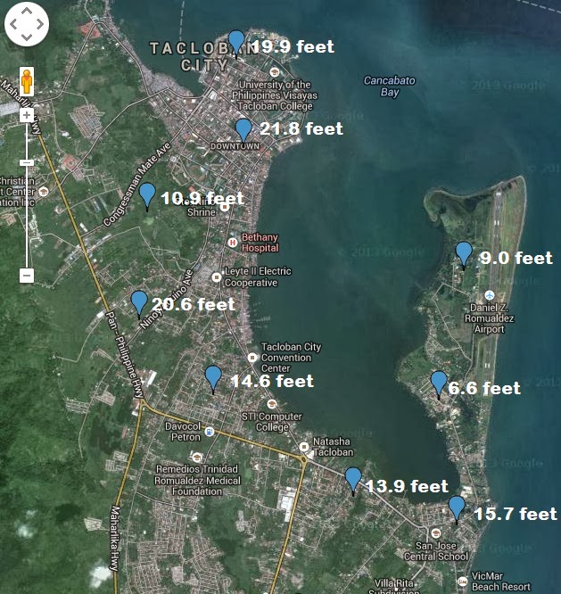 |
| Elevations Tacloban City |
It's instructive to take Yolanda's experience and map it back into the United States. This, for example, is an elevation map of Cape May County on the southern tip of New Jersey.
 |
| Elevations Cape May New Jersey |
North Wildwood, Wildwood, West Wildwood, Wildwood Crest, Diamond Beach, Cape May, West Cape May, North Cape May and Villas would all be flooded and swept off the land by a Yolanda or Katrina type event -- 30,000 housing units gone, finito, out of there.
Moving up the coast and into Manhattan, the impacts would be devastating.
 |
| Elevations, Downtown New York City, Manhattan Island |
A major system would flood all of downtown up to the Brooklyn Bridge. The World Trade Center site would be awash in the sea. The New York Stock Exchange would flood and the Manhattan subways would be for the fishes.
These are impacts that will occur someday. People had better be prepared for the evacuation and property loss. Whether it will be next year, the next decade or a century or more from now no one can say. That's the risk of locating along the ocean shore.
No comments:
Post a Comment